28 May 2009

OLINDA: 14KM NATIONAL PARK AND ARBORETUM WALK

On Sunday 24th May, we walked at Olinda, through the Dandenong Ranges National Park and the RJ Hamer Arboretum. You can see the map by clicking here. It was SJ’s birthday present to herself: a triumphant return to conquer the Walk o’ Doom!


View from the start of the walk, 9:30am.


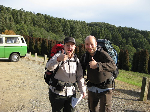
Me and DB give this the thumbs up already! (Photo by SJ)


The route follows unsealed tracks and unsealed footpaths, it includes some steep ascents and descents. Although it is only 14km long, I would rate it as one of the more difficult walks we’ve done. This is mainly due to the constant climbing/descending: there is very little distance covered over flat ground. It is also to do with walking on bush tracks and footpaths, which are often uneven, slippery with wet leaves, or obstructed by fallen branches and overhanging foliage – it takes a lot of mental energy to continuously pay attention to where you’re walking. I slipped over at the start of the walk, landing on my bum and pack (good reason to have a nice big pack, to buffer the landing) jarring my shoulder and bruising my hand. Going down steep hills is hard!


I think this was just before I fell over! (Photo by SJ)


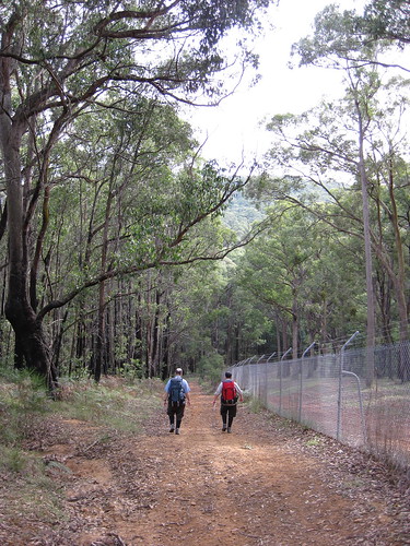
Board track, beside the grounds of Silvan Reservoir


The other reason I’d rate this harder than average is that the Melways maps, the maps from Parks Victoria and Google Maps often don’t match up, or show conflicting information, thus some small amount of navigational skill is needed to route find. For what it’s worth, if you are going with one map only, I’d use the Parks Victoria one because although it doesn’t show all the tracks, the ones it does show are in the right places. I love maps.


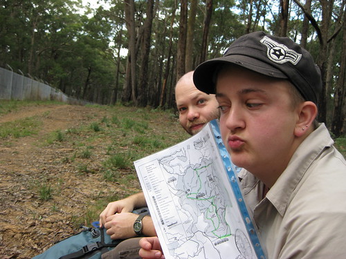
Yes, I do like maps! (Photo by SJ)


We crossed paths with two or three small groups of bushwalkers, and amused ourselves by talking about feral park rangers turned cannibal jumping out and attacking bushwalkers with chainsaws. THAT WAS FUN. We also talked about how if you were going to eat a member of your party, you would totally start with their arms, so they could still walk. Ummm . . . *shifty eyes* WE'RE NOT REALLY THAT CREEPY, I SWEAR! OK, maybe a bit. Anyway! We saw a shitload of bikers going down hills at top speed. That way lies broken collarbones, people! DON'T DO IT! We also gave directions to a couple of chaps who were strolling around clutching bottles of beer - we knew we were getting close to the end when we started seeing people in jeans walking around! However, for the most part this was a gloriously quiet walk, with just us, the trees, the ferns, the birds and the water to make noise.


DB with a tall tree


Last time we walked here, we were absolutely knackered at the end, and went to E’s mum’s place and fell asleep on the couch! This time we did a longer route (14km instead of about 11km), and I think we avoided the very steepest section of last time. Mind you, it was still rather steep in parts!


Note the sweat! It was pretty steep!


We definitely noticed an improvement in our endurance and recovery, though, because this time we were not completely wiped out, and in fact still had the energy to sing Beatles songs at the top of our lungs (substituting lyrics to make them even creepier than they are) on the way home. It’s nice to know that we’re getting better, especially as D & I were carrying our big packs this time (full of phone books!)


D & SJ heading uphill after lunch.


In conclusion, this walk is highly recommended, especially in autumn as the leaves from the deciduous trees in the arboretum are changing and falling (I’d suggest April-May as a guide). It is lovely to see the contrasts between the drier bush, the rainforest in the creeks and the European/Asian/American trees on the slopes. This walk has gorgeous views at the start and also climbing out of the valley at the end, and gives a great sense of accomplishment to complete.


View back over walk and valley (Photo by SJ)


View back over the arboretum and national park


I would recommend a shorter walk (down to Valley Picnic Ground and back, or a less steep route involving driving to the bottom of the valley) to people who don’t have a moderate level of fitness. You need to take ample food and drinking water, as none of the water en route is potable. There are BBQ and toilet facilities at the start/end and at Valley Picnic Ground. The walk is not PT accessible, and is not wheelchair, scooter or pram accessible.


SUCCESS! Us at the end of the walk!


More of my photos can be found by clicking here.

SJ’s new camera can be seen in action by clicking here.

Happy birthday, SJ!

26 May 2009

FREE SEMINAR ABOUT MAPS AND STUFF!

Judith Collard (University of Otago)

"Mixing History and Science in the Maps and Diagrams in Matthew Paris and Ranulph Higden's illuminated chronicles."


This research comes out of a wider project on the illumination of History in English medieval chronicles. In my recent research trip to Europe and the US I have been examining the manuscripts of Matthew Paris and Ranulph Higden. One of the surprising aspects of examining illuminated English chronicles is the breadth of imagery found within them. Not only are there narrative scenes and decorated initials, such works also contain a range of diagrams from mappamundi to genealogies to the scientific. These were derived from a variety of disparate sources. Individual elements have received attention, but have generally been read in isolation, often without regard to the historical text that they accompany. This is particularly the case with maps. While many of the texts have been published, the visual apparatus existing within and around these texts are rarely discussed or reproduced by either their editors or later art historians. My focus in this talk is on these diagrams and the challenges they present to modern ideas about medieval chronicles.

Wednesday May 27, 4.30-5.30 pm, Theatre 1, Economics & Commerce Building, University of Melbourne (Parkville campus)

This seminar is free of charge and open to all staff, postgraduate and undergraduate students and members of the public.

Judith Collard is a senior lecturer in Art History and Theory at the University of Otago. I studied at Melbourne Uni and Latrobe and am currently an honorary fellow in Fine Arts. I teach both medieval and contemporary art history at Otago and my most recent articles include work on Matthew Paris and the Flores Historiarum and appear in Zeitschrift fur Kunstgeschichte and Studies in Medieval and Renaissance History.

22 May 2009

SUNDAY 24TH / SATURDAY 6TH

This Sunday, we will be walking in Olinda. Click here to see the planned route. It is a circular walk of about 13kms on unsealed paths and roads, with lots of gentle gradients and one whopper hill - you start and end at the top of it at a lookout/carpark. It is not particularly accessible by public transport, so you will need to drive yourself there, arrange a chauffeur or use a taxi.

On Sunday 7th NOW SATURDAY 6TH June, we will be walking along Melbourne's dismantled Inner and Outer Circle Railway. Click here to see the planned route. This is a one way walk from Royal Park Station near Melbourne Zoo, through Brunswick, past the Fairfield Boathouse, through Kew, Hawthorn and Malvern to Oakleigh Station. The full route is 25kms, but there are plenty of public transport options for a shorter walk: 4 trams and a train in the first 4 kilometres, trams at 10.5 and 12.5 kms, and several train stations beside the path from 14 to 22 kms. I believe all transport options are in Zone 1 (or on the border). The route is primarily on sealed paths, although there are a few sections where we will probably walk alternative, unsealed tracks (also note that an alternative route will need to be used between Heidelberg Rd and Chandler Hwy for those using mobility aids: wheelchairs, scooters, walking frames).

*


Please email or leave a comment here with your contact details if you'd like to join us, and we will talk re: starting times, places, etc.

*


THE USUAL LIST OF THINGS TO BRING:

If you want to join us, you will need to bring the following things. This list may seem very serious business, but you do not want to be caught without these basics.

Water. It’s really important to have enough to last you either the whole walk or until the next water-point. For a full day walk without any water points, you will need AT LEAST one litre, with more waiting at the end. Carrying two 600+mL bottles is advisable.

• Good, broken in walking shoes (cross trainers or sneakers are fine, sandals only on city walks, hiking shoes or boots are excellent so long as they’re broken in)

• Appropriate clothing (jeans aren’t great, and be aware of thigh chafing if you wear a skirt or dress)

• Appropriate weather-specific gear, especially on long, remote bushwalks – what you carry is all you have (minimum in all autumn walks: raincoat, scarf, beanie; sunhat, sunglasses, sunscreen)

• Bandaids for possible blisters, Ventolin if you need it, and consider bringing a small first-aid kit on remote walks (painkillers, disinfectant, bandages, any specific medication you might need)

• High energy snacks (nuts, dried fruit and chocolate are the usual recommendations)

Lunch! This is clearly the most important bit! Usually we bring a thermos of tea (please BYO tea or coffee!) and a variety of tasty vegetarian morsels to share. Leftovers, legume-based salads, potatoes, rice dishes, quiche: all these are delicious. Let us know your dietry requirements, and remember your cutlery!

Enthusiasm and willingness to talk about random shit, a camera, your phone so you can text people and say you're eating lunch on a mountain or something.

A sense of your limits, and confidence in voicing them. There is no shame in having to stop to rest – in fact it is very important. We always pause at least once or twice to “look at the view” when we’re going up a hill! If things are getting absolutely too difficult, there is almost always the option of a shorter route, catching public transport, getting your chauffeur to pick you up early, calling a taxi, or turning back.

Water. Don’t forget it, or I won’t let you walk with us. *Bossy/serious man is bossy/serious*

17 May 2009

KISSING GATES

DB and I just finished watching Julia Bradbury's Coast-to-Coast walk series, and in the last episode she goes through a kissing gate with another person. AND THEY DON'T KISS! IT'S THE LAW TO KISS AT A KISSING GATE! Well, that's what we decided some years ago, and so now whenever we walk by ourselves or with others, we have a train of kisses passing from one member of the party to the next. It's fun! Anyway, we weren't sure why kissing gates have that name, so I typed "why is a kissing gate called a kissing gate" into Google, and the Wikipedia entry told me:

The name may be associated with a traditional game played when more than one person is passing through a kissing gate. In order for one person to pass fully through the gate they have to close it to the next person. At this point, when the two are on either side of the gate, the person in front "refuses" entry to the second person until presented with a kiss. Indeed in some circles it is considered good form for everyone passing through a kissing gate to exchange kisses in this way (provided all parties are sufficiently friendly with each other).


I'm quite amused that we came up with this completely separately. I guess it's not that odd, really, since what else would you do at a kissing gate but kiss?

15 May 2009

MISCELLANEOUS STUFF

I've been using friendly places to look for queer-friendly (well, 'gay & lesbian friendly', which I hope means the same thing) accommodation in the UK, or to check if accommodation we've already booked is listed there. They also have categories like 'walker friendly', 'diet friendly' (i assume this means veg*n rather than OMG-I-CAN'T-HAVE-THAT-MANY-CALORIES), 'child & family friendly' . . . and water sports friendly. tell me it's not just me that finds this amusing - who knew that kink was so popular they mentioned it in accommodation guides!


click to enlarge


*

I've got some new orthotics. They're amazing! Compared to my old ones they are much more contemporary, they are narrower at the front (no more poking through my shoes), they are lower around the heel (no more hurting my feet and making huge calluses that I need a Ped Egg to get off!), they have these awesome cushiony bits in the heel (shock absorbers!), and they have heel stabiliser underneath (so my foot rolls inwards less). Maybe I'll take a picture and show you a comparison!

Anyway, I went to see Sarah at Vigor Clinic on the corner of Smith St and Kerr St in Collingwood. She is exceptionally lovely, listened to my concerns, explained exactly what she was doing and why, went through what to look for in shoes, and was generally one of the nicest health professionals I've seen (and definitely the nicest podiatrist)!

*

Here's a couple of questions for you. I'd love to hear your answers in the comments!

1. Why do or don't you walk?

2. What would you most like to see (as a tourist, ex-pat, temporary or long-term resident) in a walking book about Melbourne?

3. What kinds of things are important for you to know when you go on a walk? (e.g. history of area, location of cafes, hills, first aid, what food to take, etc.)

4. What is your favourite walking book? Why?

5. How many walks do you think would be enough in a book? Why?

14 May 2009

THORNBURY PARKS CIRCULAR WALK: 10 MAY 2009

On Sunday, HAWT was joined by E (and again by B the dog) for a 10km walk around Thornbury – with a bit of Preston and Northcote thrown in – taking in some of the smaller green spaces of the area. We headed off at around 9, and IIRC we finished a bit after 12, and ate dozens of delicious vegan chocolate biscuits made by SJ on the way.

The walk had a couple of objectives. The first was to scout out the area and become a bit more familiar with the public spaces, and in this it was successful – we discovered lots of parks, playing fields and reserves, and we also got a good overview of the accessibility of play equipment and facilities in the area. The second was to provide a less-strenuous walk than our last 25km epic along the Yarra, hopefully providing an opportunity for some new walkers to join our group (and not to break them like we almost broke SJ on the Olinda Walk-o-Doom last January). I think we also succeeded in this, as E joined us for the first time and seemed to make it to the end without dramatically falling into a heap or hating us forever!

Some pics (more on flickr):

cute beardy!
Beatrice . . .

b BRAVELY makes a friend
. . . bravely makes a friend . . .

the after shot: OM NOM NOM BISCUITS
. . . but misses out on a chocky biscuit!

FORK SALE
An amusing sign alteration.

Grandview Dairy
Grandview Dairy. No longer a dairy, and with less of a view than in halcyon days.

e surveys the feast!
E, surveying our feast!

supersexy modelling, playground edition
J, demonstrating this particularly rude piece of play equipment.


Review of Thornbury parks circular walk

I found this walk a little less exciting than usual, personally. I think it might have been because as a circular, suburban walk there wasn’t quite the same sense of discovery or progression as some of the creek/river/hill walks – almost everywhere we walked would also be accessible by car. However, there are many good aspects to this walk, too:

• It is very family/kid friendly (I can imagine how fun it would be to play on all that play equipment if I was a kid . . . what am I talking about? It was exciting for me as a so-called grown-up!)
• It is accessible to people with mobility issues, people using wheelchairs and/or prams (you can stay on evenly surfaced, sealed pavement the whole time, and there is only one ascent and one descent of significance);
• There are lots of water taps and 5 public toilets on the walk (I did notice that one set looked very closed, though, and I didn’t check if they were all wheelchair accessible or gender neutral);
• It is quite dog-friendly (although you would want to keep them on a lead near the main streets);
• Towards the end it goes past a strip of cafés on High Street, so if you are ready for lunch you could stop off for a coffee/tea/whatever and a bite to eat!
• It is well-serviced by public transport, so you can cut the walk short at numerous points if necessary; and
• It is circular, so you can start/finish at any point you want, and go in whichever direction pleases you.


Map of Thornbury parks circular walk

10 May 2009

RACE AND WALKING

It often strikes me that walking (and particularly long-distance walking in Australia and the UK, walking in the country, walking for leisure) seems to be a very white pastime. I've been thinking about this for a while, now. Walking gear is advertised by white models, walking trails are advertised with pictures of happy white people, the author photos at the back of guidebooks show white faces smiling out at the reader, walker-friendly B&Bs are run by friendly old white couples. I have not thought very deeply about what this means (I have the privilege of not having to think about it whenever I go walking), but I was still interested to read an article in the spring edition of Walk Magazine called Rural Minority Report.

The issues that are addressed in the article (which is about the UK, as the Ramblers is a UK organisation) include:

* The perception of the countryside being "a place for the rich, white upper classes. All the land belongs to farmers and any black man caught trespassing will be shot".
* A "real knowledge gap" within urban-dwelling PoC communities (i'm a little leary of the acronym BME used in the article) about the countryside.
* A lack of visibility of POC using or being in the countryside. "One criticism levelled at British tourism boards by racial-equality campaigners is that much of their advertising features white people enjoying the outdoors, further alienating BME groups by reinforcing the notion that certain places aren’t ‘for them’."
* Racism. "While overt racism is rare, non-white faces in some areas still provoke a reaction".
* "[R]eal physical barriers prevent[ing] people accessing the countryside" - that is, lack of public transport, the cost of public and private transport, and the difficulty of deciphering public transport timetables especially for those people for whom English is a second or third (or fourth, or fifth) language.
* No habit or family history of going to the countryside.


I think the article is slightly problematic in its approach (quoting white people telling stories about PoC is one example that sits uncomfortably with me and another is the emphasis on the 'worries' PoC have, with less acknowledgement of the actual racism they experience) but I am glad that at least the issue of racism in walking and racism in the countryside is being addressed.

It's something I have also noticed when watching walking documentaries. As much as I have enjoyed Julia Bradbury's Wainwright Walks, and have been very happy to see an active, not-dolled-up woman talking to other women in the countryside (I'm sure the show has even passed the Bechdel test a few times), I've also noticed that most (if not all) of the people featured in the interviews have been white. It was also interesting to see (and later read) Griff Rhys Jones talking to some black walkers in his show Mountain:

It was startling and dreadful to notice how incongruous black walkers seemed. I realized that I had seen so few black people out on the hills and had sort of accepted it unthinkingly.

"But that's what we believe," Donald said. "People think a black man out walking looks odd. So how do you think a black person feels? We have to get people to realize that they can get out there and walk and that's why we go together in a group." (2008:198)


~*~


I'm usually quite apolitical on this blog, I think, but it's important to recognise that travel and walking are not apolitical activities. Anyway, maybe this is some food for thought for your next walk - unless you're a PoC, in which case you probably already think about it when you're walking (much like I am very aware of being queer and trans).

6 May 2009

DIAMOND CREEK & YARRA WALK: SUNDAY 26TH APRIL

OK! I thought it was about time I made a post about our walk 2 weekends ago! I’ve already made one short post about it.

Here are more pics from the day, including one of a goat.

NOTE: This Sunday we’ll be doing a very different and much shorter walk around Thornbury/Preston/Northcote, scouting out small green spaces. Here are the details if you should want to join us. We start at 8:30am, please email for a meeting place!

***


So, SJ picked us up early, and drove us to Eltham, where M and L put on an amazingly delicious breakfast for us. Seriously – gently scrambled eggs with delicious fetta, perfectly roasted tomatoes, mushrooms, home-made soda bread and coffee from their espresso machine. WOW. I am so sad I didn’t take pictures, but I was too busy nomming!

the before picture: d, sj, l &m
D, SJ, L and M by Diamond Creek at the start of the walk.

We didn’t have a map, as L and M had walked down to the Yarra a few times before, and the trail looked quite clear along the Yarra (on Google Maps!) up to the point where we had walked previously (see the last entries on this page and this page). It was good to have people who knew where they were going, as it meant we got to see some of the nicer parts (there’s the option of walking on either side of the creek at some points). For the most part it was fine. There were a couple of moments when it became confusing, but we didn’t worry about it too much – keep the river on the same side and you’ll be OK! You may laugh, but we did actually use that piece of wisdom during the day.

sj and l present: the tiny sign!
SJ and L with a tiny road sign.

"almost like england"
“It’s almost like England!” This was a lovely little section.


We got to walk under the gorgeous wooden trestle railway bridge where the train crosses the creek in Eltham, and for those interested in trains and suchlike, we also walked past the miniature railway! There were lots of interesting things along Diamond Creek, and if you wanted to do a shorter walk, wandering down to the Yarra and back in a day checking out all the activities could be fun.

one point perspective, wooden bridge over diamond creek
The bridge over Diamond Creek. I like bridges! Who knew!?

miniature railway FTW!
The miniature railway at work!


At the junction of Diamond Creek and the Yarra, we stopped for a cup of tea and a snack. I should of course add that M and L are lovely, and were very good to walk with. I talked to L quite a bit about places to live, travelling, whisky and all manner of important things such as that as we walked, and I remembered that being engrossed in conversation can really make the distance fly by. L and M are both keen walkers, and I think this was the first time that HAWT has walked with someone who has more intimidating shoes than ours – M’s Scarpas were pretty hardcore! I think the walk was slightly puny to M, who has done the 100km in 48hrs Oxfam walk, but he was a good sport about it!

tree . . . !
I liked this tree! with its very own exclamation mark!

the yarra, looking east
The Yarra River, looking east from the footbridge.


We stopped for lunch at our favourite playground, nommed on quiche and soda bread and other delights, made lewd jokes, stamped on the musical bridge (seriously, guys, the playground is AWESOME), filled our water bottles, then donned our raincoats as it started raining just as we left. Here, have some pictures of the playground from last time we were there:

walk march 08: play time!

walk march 08: mirrormaze, longlegs

It was actually a good thing that it started raining, and then continued to rain off and on (and not just a light drizzle for a lot of it) for a lot of the rest of the walk – it is actually the first time that HAWT (or me and D) have encountered anything approaching serious rain on any one of our walks! We have generally been extraordinarily lucky with our weather. However, D and I don’t believe that we will be able to make it for 2 weeks along the southwest coast of England in September without any rain, so we damn well want to practice! The rain meant that the path was pretty much cleared of other walkers and cyclists, too, which was lovely. The only problem with rain is that it means I put my camera away and don’t take photos, so here are the final two of the walk.

bridge over the yarra: slippery when wet
Slippery when wet. When we re-crossed after lunch, it was raining!

waterproofed: l, m, sj, d
L, M, SJ and D in their waterproofs.


Our plan with this walk was to walk as far as we could, with the vague idea of making it to the Fairfield Boathouse. In the end, we decided against it, and although we didn’t know how far we’d walked, that was a sensible decision! From Burke Rd, instead of crossing the river and walking beside the Eastern Freeway and then through Yarra Bend Park to the boathouse, we stayed on the north side, walked through the gorgeous Chelsworth Park (according to Google, anyway!), then up to Ivanhoe Station. The last bit up the hill to the station along paved footpath was a killer! I was wearing my big pack for the first time to start training, and I had to get DB to carry it for a kilometre while I carried his, much lighter, pack. From the station, we caught the bus straight home, while SJ caught the train with L and M back out to Eltham to pick up her car.

I mapped our walk and discovered we’d walked almost 25kms! That is possibly the longest HAWT has done in a day. No wonder we were so ratty by the end! By the looks of things, Fairfeild would have been an extra few kms, plus the walk to the station afterwards. I’m glad we didn’t attempt that!


Review of Eltham – Diamond Creek – Yarra – Ivanhoe walk.

Unlike many of the creek and river walks we have done, this one did not feel like we were in suburban residential areas (apart from a section near the station at the start and walking up to Ivanhoe Station at the end). Rather, we went through native bush and developed parkland, past small farms and ‘undeveloped’ land, between ovals and playing fields, around golf-courses. This natural aspect is a very nice element of the walk, and if you happen to be walking on a rainy day you might not even see a soul over some sections of path, further enhancing the sense of distance from the city.

The path is generally flat, and the biggest ascent was to Ivanhoe Station – at which point you climb to approximately the same elevation as you started – what took 23kms to descend now takes 2km to climb! That said, there are enough points of interest and places to get views, so you don’t feel like you’ve been walking in a tunnel the whole way. The path surface ranges between sealed and unsealed, but even the gravel is very even and well-maintained. Just after our first crossing of the Yarra, we took the smaller trails closer to the river, rather than the main trail. This was more interesting, and the trails were good but not excellent – if you have mobility issues I recommend staying on the main path. The main challenge of this walk, for me, was the distance. Remember to drink enough water and replenish your sodium, folks, or you might end up with a cramp! Also, pay attention to your feet and if you feel that pinching bite, take your shoes off and put on a bandaid before you get a blister!

There are a lot of lovely sections in this walk – almost too many to pick a few highlights. I personally enjoyed the section between Yarra Valley Metropolitan Park and Warringal Park, where the path meanders away from the river past the wetlands, and you can go through some kissing gates. KISSING GATES! At any rate, this walk (or a shorter version, if you’re not too keen on walking 25km) is recommended, especially if you’d like to be surrounded by nature.

5 May 2009

THORNBURY WALK THIS SUNDAY

If anyone would like to join HAWT (Handy Acronym Walking Team) for a walk around parts of Thornbury (heading into Preston and Northcote at times) this Sunday morning, leave a comment or email for times and our meeting place. We will probably start around 8:30am or 9:00am, and the walk will take a bit over 3 hours.

The planned circular route is about 11kms, and is designed to find some of the small parks and gardens in the area. The route will include a few gentle ascents/descents, and as far as we know it will all be paved. Nearby trams include the 112 on St George's Rd and the 86 on High St, and number of train stations are also close by. Buses include the 510 Ivanhoe-Essendon.

Please bring weather appropriate clothing, comfy shoes (sneakers are fine), water, any medication you might need, and a snack. We will be in the vicinity of a number of cafes and might stop for a coffee during the second half of the walk. Please eat something for breakfast before we walk!