28 April 2009

"I FORGOT ABOUT THAT"

We walked about 25km on Sunday! We went from Eltham, down Diamond Creek to the Yarra, then along the Yarra and up to Ivanhoe train station. Full post to follow when I get around to uploading photos.

From the "I forgot about that" files, for future reference:
* That little pinching feeling on my little toe? It is probably a blister. I need to remember to take my boots off and apply a bandaid immediately!

* Same goes for that pinching feeling on my instep . . . even if I don't think it's a place a blister SHOULD be, it's still probably a blister!

* Water is good. Drink it.

* Replenishing sodium is important. Do it.

* Warm-downs are VERY important. If you don't do enough you will end up with a thigh cramp in the bath! Painful and hilarious!

* Don't hike in worn-out boots. I'm going to the podiatrist today to hopefully get new insoles (usually this takes a couple of weeks). Once I have them, I will be buying some new boots, as the sole on my pair has worn through.


Despite this list, I had a good time! Yay for walking.

21 April 2009

THIRD TIME LUCKY: GELLIBRAND HILL

It's a curious thing that walking the same path feels like it takes far less time on the second outing, but walking the same 800m route to the tram stop seems to take forever even after doing it several times a week for 3 years. In the first case, it might be something to do with not stopping to take so many pictures. But I suppose it might also have something to do with knowing what's coming and where we will stop (we took morning tea and lunch at the same places as last time). On this particular adventure, it might also be a result of having 5 people in our group, and thus chatting the hours away!

This walk was a close copy of our ill-fated first attempt a couple of weeks earlier. HAWT was once again joined by G (we all looked at his elbow and went 'ooh' and 'ew', etc) and also by J (as this might cause some confusion, I will call myself N for nix in this post). We met at 9:30am on Good Friday where Moreland Rd crosses Moonee Ponds Creek, allowing me and D to catch the bus instead of a taxi.

before: g, j, sj & d
G, J, SJ & D setting off.


We made pretty good time along the path, knowing that a delicious morning tea of freshly made hot cross buns (SJ is a genius, I tell you) awaited us. The weather was slightly cooler than on our previous attempt, with some occasional and very welcome cloud cover.

threatening silhouette walkers are threatening!
J, SJ & D lurking under the bridge.


Morning tea spot. Photo by G.

hot cross buns with golden syrup glaze
Amazing vegetarian (i.e. golden syrup glaze) hot cross buns by SJ.


Over morning tea (we felt quite pleased with ourselves for eating holiday-appropriate food), we discussed the idea of making a book combining our passions: food and walking. We thought we would call it Baked Goods and Bridges I Have Known. What do you think?

After that, we trundled along through the suburbs on the other side of the creek from last time, under the trestle bridge (we stopped to admire it again, but not for as long) and into the Jacana wetlands. We paused for a standing snack (dried fruit) to keep up our energy until lunch, which was not too far away!


d, j & sj cross the creek
J, SJ & D crossing the creek at the stepping stones.


D, N, SJ & J heading towards the trestle bridge. Photo by G.

hikers' banquet!
Lunch! It was a very successful banquet!


Lunch was delicious - roast potatoes, fried rice, veg sushi, cornbread with honey, carrots and cucumber with dip, and chocolate to finish it off. NOM NOM NOM. After lunch, we continued with some trepidation past the site of G's accident on our last walk. All went without incident (yay) and we crossed the creek into CFA land: THE COUNTRY! I wanted a photo to commemorate the occasion, and I said I'd photoshop myself in later. I didn't but G kindly did:

"i'll photoshop myself in later"


Hot! From here, the path climbs gently through some messy but interesting semi-wasteland to the foot of Gellibrand Hill, affording a view over the creek towards the airport (there is some runway noise at points). It seemed quite soon that we arrived at the wildlife fence and passed through the gate into Woodlands Historic Park. It's nice to finally be in amongst the trees, especially when it's sunny and you're beginning to sweat off your sunscreen!


Thistle plants. Photo by G.

into the wildlife PRISON
G & SJ go to visit J & D in their wildlife prison!


The ascent coming at the end of the walk was hard, but thankfully it isn't too long or too steep, and we were rewarded with kangaroos as we started the final climb up Gellibrand Hill past the radio tower!

kangaroos on gellibrand hill


And then, the top of the hill! There were a couple of other people around, but we mostly only shared the view with the kangaroos, a cup of tea, and more hot cross buns. Given that the hill is only 204m above sea level, it does give you very good views almost all the way around. Unfortunately it was a bit hazy when we were up there, so the city was muted blue and silver on the horizon, but we pulled out the map and charted where we'd come from.

d is a mountaineer!
DB at the summit! What a peak-bagger!


Panorama by G.

ideas for next peak-bagging adventure?
More ideas for walks and views!


We poked around the Dundonald Homestead ruins for a bit, scared a few rabbits, admired some trees and some walls, then headed down to the main road and waited for the lovely E to pick us up. I don't know how she puts up with our stinkiness, honestly!

g on the stables at the dundonald ruins
G admiring the stables. They were better preserved than the house!


All in all, a successful adventure. No injuries, lots of good food, lovely people and a view at the end!

Review of Moonee Ponds Creek Trail

Now, a couple of people have mentioned to me that I don't really rate/review the walks we do and the trails we use. I guess that's because I started out doing this as a diary rather than as a review site, and also because I enjoy walking and discovering things to such an extent that it doesn't matter that much where I do it (with massive exceptions, like the UK being much more walker-friendly than Australia, or mountaineering not being the kind of 'walking' to which I aspire)!

That said, I guess this path is not one of the most attractive/interesting waterside trails in Melbourne - it is pretty flat aside from a very wee climb in the middle and the hill at the end, and apart from a few sections of creek and Woodlands Park at the end, there aren't a lot of nice tree-filled areas. However, it does have one major thing going for it: a sense of progression. I must admit that I am a total sucker for walks that take you from city to country, and the Moonee Ponds Creek Trail (with the extension to Gellibrand Hill) does that magnificently. You start on the edge of Brunswick and walk along the creek through outer suburbia in all its glory - Citilink overhead, the 1970s brick units, the TV antennae, the dry ovals, the new housing estates. Then there's the giant trestle bridge, which quite frankly makes the entire walk worthwhile! You hit the long, exposed basin of the Jacana Wetlands, and there's a good chance of seeing some interesting birdlife on both sides of the Western Ring Road. This section is something you should particularly note, as a proposed freeway extension may soon make a huge scar alongside the valley. From there, the path curves away to the west and takes you through the last of the suburbs (Westmeadows), out of MFB territory and into CFA territory.

At this point of unclaimed, BMX-track and rubble-strewn land you start a gentle but noticeable climb, and you can see the Tullamarine Airport and Age buildings close by. Crossing the into Woodlands Historic Park, you follow the fence north for a way, with bush and scrub to your left and horse paddocks to your right. Gellibrand Hill has been in view for a while, and now you curve around the bottom to approach it from the north. If you're lucky you will see a mob of kangaroos grazing and lazing near the radio tower. Although it might be tempting to cut directly up the hill from the south, circling around means that you are rewarded right at the end with a magnificent view back towards the city. If you have OK visibility, you can trace the route you've walked and congratulate yourself on how far you've come over a cup of tea.

I give the walk THUMBS UP!

moonee ponds creek walk: thumbs up!


More of my photos from the day can be found here. An approximate map can be found here.

12 April 2009

PHOTODUMP: 15TH MARCH: MERRI CREEK WALK

this is the walk that we took up the merri creek to the western ring road a month ago. bea, the scruffy dog, came with us and kept up well for the 18kms.

HAWT + 1

path after rain

tree & fenceline

we walked to the end of the path!

a few more photos can be found here, and here is an approximate map:

8 April 2009

WOODLANDS HISTORIC PARK WALK

So, before we set off on our third attempt to walk to Gellibrand Hill, I thought I’d post a few pictures of the last time we were in Woodlands Historic Park. First, a map:


We had originally planned to come back from the Port Fairy Folk Festival on the Monday, but E was ill, so we came home on Sunday night, thus leaving us with a spare day. So SJ, D and I drove up to Woodlands for a shorter walk – we had a time constraint.

the usual 'before' picture

We first headed in a bit of a roundabout way to Woodlands Historic Homestead, where they keep old champion racehorses, I guess so they (the horses) don’t get sent off to be made into glue/dogfood.

woodlands homestead: please shut gate

At the homestead they also have a little coffee-spot, which was a welcome surprise to us, and is worth keeping in mind for longer walks. The homestead isn’t far from the major carparks, however, so it would probably not work so well as a lunch spot, unless you were lunching before going on an afternoon walk, or at the end of a morning walk. The grounds are quite nice, there are toilets (including an accessible toilet), and friendly magpies to keep you company.

magpie at woodlands homestead 2

We also did a bit of an off-path wander to get to the top of the rock at the top of the hill behind the homestead, which afforded us views of the sweeping horizon, particularly to the north and west.

we left the city behind

on this loveliest day of days

Once again, our Melways map didn’t quite match up to the maps beside the trail, and neither of them quite matched up with what was on the ground. Nevertheless, we found the wildlife fence without too much angst, and once inside we saw a mob of kangaroos grazing close to the path! No Eastern Barred Bandicoots, though.

any damage will reduce its effectiveness

We wandered down towards Gellibrand Hill, getting ever closer to the runways of Tullamarine (Melbourne) Airport. It was quite bizarre to be wandering through this peaceful bushland, then look up and see a jet coming in to land!

smell the serenity: woodlands vs tullamarine

In the end, due to time restrictions, we gave Gellibrand Hill a miss, opting to have a leisurely lunch, then walking quite speedily alongside the fence most of the way back.

d & sj, rehydrating in the blazing sun

We did pause, though, when we saw a pair of Wedge-tailed Eagles right beside the path. THOSE THINGS ARE BLOODY BIG!!! It was quite exciting to see them both perching (roosting? sitting?) in a tree/on the fence, then watch as they took off. We were close enough to see the size of their legs, too. I don’t have pictures, because I was too busy looking!

We also passed a horse and rider – the horse being extremely jumpy and shy, we gave them a wide berth, then took a short cut that actually worked (!) back to the carpark. It was a good day.

More photos can be found by clicking here!

*

You might also notice that we have a new recruit to walking in our sidebar: Nicholas (who I visited in Italy), and his blog Ambulation of Mind.

2 April 2009

... AND WE ENDED UP IN EMERGENCY!

Last Sunday, G joined the usual HAWT* crew for a walk up the Moonee Ponds Creek, along the bike trail. You can see the pics I took on G’s camera (forgot my own) here. Our aim was to walk along the creek to Gellibrand Hill in Woodlands Park, as per this post.

We met at 9am where Moreland Road crosses the creek. For future reference, the first bus heading west on Moreland Rd on a Sunday leaves from Sydney Rd and gets to the Creek at about 9:30, and if you want to go from High St, you have to wait longer. D and I booked a taxi instead, which cost us about $10.

After doing a few stretches, we headed off up the creek, G wheeling his bike (he was unsure if he would be able to walk the 20km carrying a pack, although he is super-fit, because of his back). We almost immediately went off track, but found our way back to the creek easily.

g, sj & d: merry gang of walkers
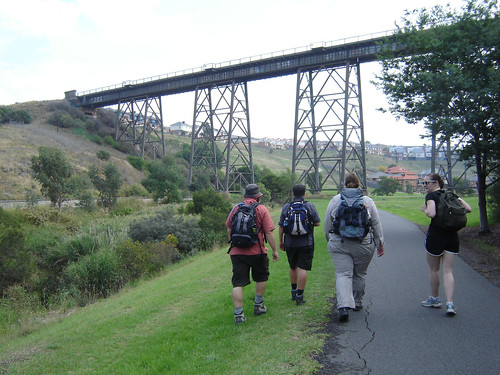
G, SJ & D on the Moonee Ponds Creek Trail. Photo by J.


The day started off with a chill in the air, but quickly warmed up, and those of us (me) who hadn’t put sunscreen on called a halt beneath some trees to slather up. Very interesting, I know. More interesting was this ‘Low Clearance’ sign near Bell St and Citylink. It is there for very tall walkers and cyclists.


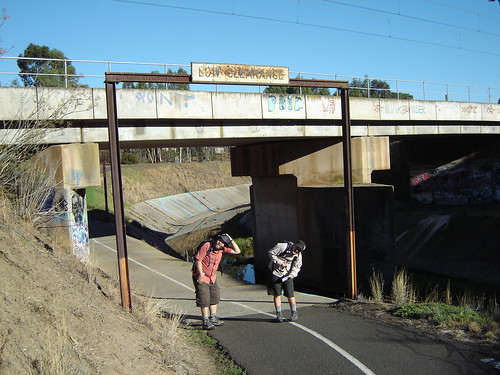
D & J duck under the ‘Low Clearance’ sign. Photo by SJ.


We stopped for morning tea in a lovely shady spot, where the main path lies further up the hill, but you can walk along the grass on the creek bank. We set up in the middle of the path, thus forcing a number of joggers to go around us. They were all very envious of our tea and the delicious Afghan Biscuits (later renamed ‘Catastrophe Cookies’) made by our resident chef, SJ.


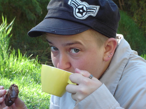
J with Catastrophe Cookie and tea. Photo by SJ.


We pressed on as the day grew warmer (I think it peaked at 25 degrees, but there was no cloud cover or cool breeze at all), and eventually the trestle railway bridge came into view. Now, you might remember that I am a bit of a bridge-fancier, and I’d been excited about seeing this bridge for a couple of weeks in the lead-up to this walk. We stopped and admired it, took a few photos, and G had a bit of a play on it. For other bridge fanciers, you can find it crossing the Merri Creek between what Google Maps tells me is Gowanbrae and Glenroy.

Trestle bridge across Moonee Ponds Creek
The trestle bridge over the Moonee Ponds Creek at Jacana Retarding Basin. Photo by J.

g swinging from the trestle bridge
G swinging on the bridge. Photo by J.

abstract: negative geometry
Abstract geometric negative shapes. Photo by J.


We walked past the estate homes and mocked them gently, but also agreed that as far as housing estates go, this wasn’t such a bad location (it’s near the awesome bridge! What more could you want?!). On the opposite side of the creek from the estate, we happened upon an interesting sight – the suburbs sprouting a multitude of antennae.

suburbab antennae
“Do you think they might have some reception issues?” Photo by J.


We strolled onwards, and eventually passed under the Western Ring Road, noting the signs for the bike path towards Merri Creek. On the other side of the freeway we continued past the Jacana Wetlands, and were surprised by a kestrel (thanks G, for your knowledge of fauna!) bursting from the grass near the path and taking off to glide above the valley. This part of the walk was quite open and sparse, and we all really enjoyed it. Unfortunately, our map told us that a new section of freeway has been proposed, running parallel to the path.

moonee reflections
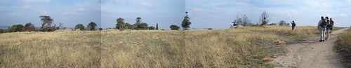
Looking South-ish, just before Western Ring Road


We were getting pretty ready for lunch by this stage (almost 1pm), but we pressed on until we found some shade, picnic benches and the promised toilets off Raleigh St in Westmedows. We luncheoned like royalty on roast potatoes with garlic and rosemary, and sweet potato, tomato and feta salad (both made by D), and amazing vegetarian sushi rolls made by G (oh my word, they were delicious). The toilets happened to be out the back of a church hall, so we were serenaded by the churchgoers’ singing as we ate.


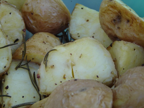
Roast spuds. Food by D. Photo by SJ.


Sweet potato, cherry tomato and feta salad with basil and red wine vinegar. Food by D. Photo by SJ.


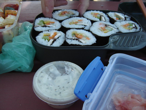
Veg sushi rolls, with picked ginger and various dressings. Food by G. Photo by SJ.


Feeling well rested and satisfied with ourselves, we set off for the last half a dozen kms to Gellibrand Hill. Little did we know, we would not make it that far. DUM DUM DUUUMMMMMM!!!

Just as we were leaving civilisation (well, we were about to walk into CFA territory rather than MFB territory), our map failed us somewhat by not matching up with what was on the ground. G kindly offered to ride up ahead to see whether one part of the path ended where we thought it did, and the rest of us asked ourselves why we didn’t bring a cyclist all the time. Our question was soon answered as G came off his bike, and we rushed to see what had happened. His elbow was well and truly grazed up, with one significant gouge expelling large amounts of blood. I emptied my waterbottle over his wound to wash as much of the gravel out as I could, then tied a hanky around it. We all walked to the nearest houses and knocked on doors until someone was home and let us use his bathroom. We cleaned G’s elbow a bit more and applied some Dettol cream (thank you, random man), and I cleaned the hanky and reattached it.

SJ called E, and she came with a first aid kit, cleaned the wound with saline, and attached a better dressing than my hanky! As we were waiting for her, we drank the rest of our tea and ate more delicious biscuits. It was at this point that we renamed them Catastrophe Cookies, because they were pretty much the ideal thing to eat at this stage of a catastrophe. E drove G and me to RMH emergency room, where we waited for a couple of hours before G was anaesthetised, cleaned up properly, stitched up, and given a tetnus booster. D and SJ called a taxi and took G’s bike back into SJ & E’s place.

Anyway, you can read more about it here, and here is a pic of G’s elbow a day later:
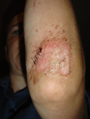

Photo by G.


It was our first real emergency on one of our walks, and although we weren’t too badly off, it really brought a few things home. First, we need to make sure to have adequate first aid for things like this, especially if we’re not going to be close to houses or roads. Bandaids and painkillers aren’t going to cut it! I have been a bit lazy WRT bringing my first aid stuff over the last few walks (mainly because I know we’re close to houses), but I will start bringing my better stocked first aid pack with me. Second, I am keen to do a first aid course. I haven’t done an official course, and while I know some basics (EAR but not really CPR, theoretically how to dress different wounds, how to splint limbs, and [my biggest fear, really] how to bandage a snake bite) I would like to know more – and especially about how to make the injured person feel safe, what to feed/not feed them, etc. Maybe it’s time for HAWT* to take our walking commitment to the next level by doing a first aid course!?

In conclusion, it was a great walk up until disaster struck! We had walked about 16km, and had about 5 to go, and we were making good time. We have decided to attempt the same walk again on Good Friday (WE WILL GET YOU YET, GELLIBRAND HILL), so if anyone would like to join us, we will be meeting where Moreland Rd crosses the Moonee Ponds Creek at 9:30am. Pretty much the same things apply as this post, so please read it over.

Maybe we will see you there, if this hasn’t put you off. WE ARE SO HARDCORE!


* HAWT = Handy Acronym Walking Team = J, D & SJ.