as much as i love griff rhys jones, and as much as i think i could probably enjoy travelling with him . . . i would never, ever let him cook.
"it's funny how spam turns doubly pink when it's cooked". indeed.
29 August 2009
26 August 2009
WOODLANDS PARK AND GELLIBRAND HILL: SUNDAY 23RD AUGUST
Map of the route
All the photos I took of the day
Click the thumbnails below to see bigger pictures!
 DB & SJ climbing on fallen tree.
 A thing that may or may not be an anthill. You decide!
 Melbourne skyline from Gellibrand Hill.
 Interesting patterns on a tree trunk.
 The stockyard at Cumberland Homestead ruins.
 SJ and DB seem to have teleported to a European meadow!
 Mystery skull! Is it a sheep? You decide!
 Cumberland Dam. We had fun going cross country for a bit.
 That's all, folks! Near the end of our walk.
But it's not all, because I want to show you this very poor quality video of a kangaroo stampede we saw! It was pretty cool!
All the photos I took of the day
Click the thumbnails below to see bigger pictures!
DB & SJ climbing on fallen tree. A thing that may or may not be an anthill. You decide! Melbourne skyline from Gellibrand Hill. Interesting patterns on a tree trunk. The stockyard at Cumberland Homestead ruins. SJ and DB seem to have teleported to a European meadow! Mystery skull! Is it a sheep? You decide! Cumberland Dam. We had fun going cross country for a bit. That's all, folks! Near the end of our walk.But it's not all, because I want to show you this very poor quality video of a kangaroo stampede we saw! It was pretty cool!
20 August 2009
INVITATION: SUNDAY 23RD AUGUST
This Sunday (23 August), we’ll be doing a shorter (11-12km?) walk around Woodlands Historic Park. It will probably be a similar route to this walk from earlier in the year, with an extra couple of kilometres in the middle, where we will walk to Gellibrand Hill to look out over north-west Melbourne.
Meet at 10am near the toilet block in the carpark off Somerton Rd (between Providence Rd and Oaklands Rd). Bring suitable clothing and footwear (sneakers should be OK for this one), and check the forecast. It’s advisable to bring waterproofs and a hat as it’s still winter and there isn't a lot of shelter along the way.
No need to RSVP, but let us know before 9:50 if you are on your way but are going to be late (leave your email in a comment and I'll send you a mobile number to text/call).
Bring a light meal and a high-energy snack (if you feel in a sharing mood, take note that many of us are vegetarian), and a thermos of tea/coffee if that’s your bag. Don’t forget cutlery if you need it! Please also make sure to bring AT LEAST one 500-600mL bottle of water, as there is only one water tap available and it’s early in the walk.
This walk is not accessible by public transport. The route is mainly along gravel tracks and paths, and it is gently hilly throughout (not very steep, but a couple of sustained climbs). There are several shorter circular-route options. If you intend to do a shorter walk, please print off a map from the Parks Victoria website (PDF map available down the bottom).
18 August 2009
ANXIOUS / PRIVILEGE
last night i had my first anxiety dream about walking. it's a tediously long "and then" narrative, with a bit of "when did you even decide to stay in the hotel? you have just arrived after walking the wrong way along the coast, and you have only just had a conversation with the travel agent about how trains to penzance only go every second day? but now you have to RE-PACK YOUR BAGS AND RUN FOR THE FERRY, YOU IDIOT!" thrown in.
on the plus side, this means we are leaving soon! yay! on the minus side, i am tired after waking up 2 hours before i wanted to be awake.
*
my friend hope has written an interesting post about the massive amounts of male privilege involved in the kind of drifting, whimsical travel undertaken by writers like bill bryson (and tv presenters, too). go and read it and comment! i've been meaning to make a related post here for a while, but i think i'll just post my comment here instead, and send you to hope's journal for discussions.
i then went on to ask: and what does it say that as i pass more and more as a guy, it's as though i find these adventurous possibilities opening up to me? it's not just "check out what i did!" coming from these narratives, it's "you could try something like this, too!" this kind of subliminal encouragement is the force of privilege at work, absolutely. most of the books are by men. white men. that's me! i can have those adventures!* and as my attitude to travel has changed, i've become angrier and sadder about the 25-or-so years of my life when there i wasn't encouraged and supported and valued as someone who could do that.
and so, as hope says, "Where are the women travellers, explorers, flaneuses (sp?) on TV?" where are the trans people drifting across europe and writing books about it? where are the people of colour walking the country lanes of england? where are the people with physical disabilities presenting international travel programs? please, recommend me some tv, some walking shows, some history/travel programmes, some adventure writing done by these people!
* although being trans complicates some things so much that it's difficult to even contemplate the logistics of them. i will post about this another time.
on the plus side, this means we are leaving soon! yay! on the minus side, i am tired after waking up 2 hours before i wanted to be awake.
*
my friend hope has written an interesting post about the massive amounts of male privilege involved in the kind of drifting, whimsical travel undertaken by writers like bill bryson (and tv presenters, too). go and read it and comment! i've been meaning to make a related post here for a while, but i think i'll just post my comment here instead, and send you to hope's journal for discussions.
i've actually been thinking about writing something on the walking blog about all the terrific adventures had in travel writing . . . by passing-as-heterosexual, cis, white men. i mean, i love nicholas crane, and i think two degrees west actually shits all over notes from a small island (or maybe i can just relate to it more?), but i'm still . . . can you see a black man easily being able to get these stories out of gruff landlords? do you think the army would treat a woman asking to cross their firing range with the same respect? would a trans and/or visibly queer person be so comfortable marching through the backwaters and presumably having to wash in public? (and this doesn't even begin to touch on the able-bodied privilege of a lot of travel in general.)
i then went on to ask: and what does it say that as i pass more and more as a guy, it's as though i find these adventurous possibilities opening up to me? it's not just "check out what i did!" coming from these narratives, it's "you could try something like this, too!" this kind of subliminal encouragement is the force of privilege at work, absolutely. most of the books are by men. white men. that's me! i can have those adventures!* and as my attitude to travel has changed, i've become angrier and sadder about the 25-or-so years of my life when there i wasn't encouraged and supported and valued as someone who could do that.
and so, as hope says, "Where are the women travellers, explorers, flaneuses (sp?) on TV?" where are the trans people drifting across europe and writing books about it? where are the people of colour walking the country lanes of england? where are the people with physical disabilities presenting international travel programs? please, recommend me some tv, some walking shows, some history/travel programmes, some adventure writing done by these people!
* although being trans complicates some things so much that it's difficult to even contemplate the logistics of them. i will post about this another time.
17 August 2009
TWO WALKS: MOONEE PONDS-WILLIAMSTOWN & BELGRAVE-SHERBROOKE FOREST
I have two walks to write up, and they are as different as can be!
The first is a 21km walk from Moonee Ponds station (9th of August 2009), down the Maribyrnong, around the Yarra/bay to Williamstown. This was a very flat walk on sealed paths, passing through some lovely suburban green spaces and some interesting semi-industrial sections. We lunched under the West Gate Bridge and spotted some dolphins slipping around the moored boats (although we didn't get any photos). The weather was sunny and breezy, there were heaps of people out enjoying their weekend, and we ate a second lunch of chips and cider in the rotunda at Williamstown.

The second is a 10km circular walk from Belgrave station (16th of August 2009), past Puffing Billy and through Sherbrooke Forest. The walk went over the hills on unsealed paths, through bush and rainforest. It was windy in the treetops, it rained for a lot of the walk, and we had to move our picnic lunch into the (very clean, very new) toilet block in order to not get flooded out! There were very few other people out and about, although the café in Belgrave – where we had tea, coffee and cakes afterwards – was doing good business.

Both of these walks are accessible by public transport. The Moonee Ponds – Williamstown walk is serviced by several train stations, making it easy to complete the walk in shorter sections. The Belgrave and Sherbrooke Forest walk is only met at a couple of points by buses (which don’t run on Sundays), but it is easy to plan a shorter circular walk of 3 or 6 kilometres. Here are the maps:
The Moonee Ponds – Williamstown path is mostly accessible to those with wheels (mobility aides, bikes, pushers and prams), although there might be a couple of minor route alterations needed to make the walk fully accessible. For instance, we did not take the available accessible path through Yarraville Gardens, and it is not possible to access our lunch spot under the West Gate due to some unavoidable steps after the footbridge.


Only small sections of the Belgrave and Sherbrooke Forest walk are accessible, and most of the path is specifically signposted and gated to prevent bikes from entering. It would be possible to walk the first 3km with a pushchair (or possibly a wheelchair), but the very start of the walk is extremely steep! The rest of the walk is mostly along narrow walking paths, and there are frequent steps. However, the picnic grounds are beautiful, can be reached by car, and have wheelchair accessible toilets.


They were very different walks for different purposes. The Williamstown walk was designed to be a long walk (for training purposes), and to explore more of the western side of Melbourne. We’d wanted to walk along the Maribyrnong for ages, so it was about time! The Belgrave walk was planned in order to show some visiting UK friends (one an ex-pat) some of the gorgeous bushland that is close to Melbourne, to give them a literal breath of fresh air and a chance to see a part of the city they wouldn’t usually get to. The hills were also good practice for us for our SWCP walk!


In the interest of getting this write-up done and out there ASAP, I am now going to do a bit of a picspam of both walks, first the Williamstown one, then the Belgrave one. Please feel free to ask me questions about these walks and I will answer them. I think that’s probably a better way to spend my time rather than writing up an in-depth journal entry that only 4 or 5 people will read!
You can see our pictures of the Williamstown walk here. (I've only used ours because it's easier to upload them). You can see SJ’s hilarious photos of the walk here, and G’s fab pictures here.
You can see our pictures of the Belgrave walk here.
MOONEE PONDS AND WILLIAMSTOWN

Clockwise from left: D, SJ, R & J. G joined us about 5km in.

We had to turn back and go over this bridge when we discovered the footbridge was out of action.

Would like to go back and explore this further.

White faced heron on the Maribyrnong

Another native!

Mazu

Stony Creek Backwash

Gull and Elvis!Gull (no idea what this bird is)

G & J making their own fun!

Mmm!

Near Point Gellibrand, looking out over the bay.
BELGRAVE AND SHERBROOKE FOREST

The before pic of the four of us at Belgrave station. From L-R: D, J, J & I.

Some of the beautiful rainforest. It was too dark and cloudy to get any really good pictures (I don’t carry a tripod!)

J drying her hair under the hand dryer in our classy lunch shelter!

The rain outside the shelter! It was pissing down, but luckily once under the trees we were fine.

Delicious tart at the aptly named Queen of Tarts café.

Another delicious tart. :O
The first is a 21km walk from Moonee Ponds station (9th of August 2009), down the Maribyrnong, around the Yarra/bay to Williamstown. This was a very flat walk on sealed paths, passing through some lovely suburban green spaces and some interesting semi-industrial sections. We lunched under the West Gate Bridge and spotted some dolphins slipping around the moored boats (although we didn't get any photos). The weather was sunny and breezy, there were heaps of people out enjoying their weekend, and we ate a second lunch of chips and cider in the rotunda at Williamstown.
The second is a 10km circular walk from Belgrave station (16th of August 2009), past Puffing Billy and through Sherbrooke Forest. The walk went over the hills on unsealed paths, through bush and rainforest. It was windy in the treetops, it rained for a lot of the walk, and we had to move our picnic lunch into the (very clean, very new) toilet block in order to not get flooded out! There were very few other people out and about, although the café in Belgrave – where we had tea, coffee and cakes afterwards – was doing good business.
Both of these walks are accessible by public transport. The Moonee Ponds – Williamstown walk is serviced by several train stations, making it easy to complete the walk in shorter sections. The Belgrave and Sherbrooke Forest walk is only met at a couple of points by buses (which don’t run on Sundays), but it is easy to plan a shorter circular walk of 3 or 6 kilometres. Here are the maps:
The Moonee Ponds – Williamstown path is mostly accessible to those with wheels (mobility aides, bikes, pushers and prams), although there might be a couple of minor route alterations needed to make the walk fully accessible. For instance, we did not take the available accessible path through Yarraville Gardens, and it is not possible to access our lunch spot under the West Gate due to some unavoidable steps after the footbridge.
Only small sections of the Belgrave and Sherbrooke Forest walk are accessible, and most of the path is specifically signposted and gated to prevent bikes from entering. It would be possible to walk the first 3km with a pushchair (or possibly a wheelchair), but the very start of the walk is extremely steep! The rest of the walk is mostly along narrow walking paths, and there are frequent steps. However, the picnic grounds are beautiful, can be reached by car, and have wheelchair accessible toilets.
They were very different walks for different purposes. The Williamstown walk was designed to be a long walk (for training purposes), and to explore more of the western side of Melbourne. We’d wanted to walk along the Maribyrnong for ages, so it was about time! The Belgrave walk was planned in order to show some visiting UK friends (one an ex-pat) some of the gorgeous bushland that is close to Melbourne, to give them a literal breath of fresh air and a chance to see a part of the city they wouldn’t usually get to. The hills were also good practice for us for our SWCP walk!
In the interest of getting this write-up done and out there ASAP, I am now going to do a bit of a picspam of both walks, first the Williamstown one, then the Belgrave one. Please feel free to ask me questions about these walks and I will answer them. I think that’s probably a better way to spend my time rather than writing up an in-depth journal entry that only 4 or 5 people will read!
You can see our pictures of the Williamstown walk here. (I've only used ours because it's easier to upload them). You can see SJ’s hilarious photos of the walk here, and G’s fab pictures here.
You can see our pictures of the Belgrave walk here.
Clockwise from left: D, SJ, R & J. G joined us about 5km in.
We had to turn back and go over this bridge when we discovered the footbridge was out of action.
Would like to go back and explore this further.
White faced heron on the Maribyrnong
Another native!
Mazu
Stony Creek Backwash
Gull and Elvis!Gull (no idea what this bird is)
G & J making their own fun!
Mmm!
Near Point Gellibrand, looking out over the bay.
BELGRAVE AND SHERBROOKE FOREST
The before pic of the four of us at Belgrave station. From L-R: D, J, J & I.
Some of the beautiful rainforest. It was too dark and cloudy to get any really good pictures (I don’t carry a tripod!)
J drying her hair under the hand dryer in our classy lunch shelter!
The rain outside the shelter! It was pissing down, but luckily once under the trees we were fine.
Delicious tart at the aptly named Queen of Tarts café.
Another delicious tart. :O
6 August 2009
BARWON RIVER WALK: 26TH JULY 2009
I should stop leaving it so long to write up these walks. BUT I AM A BUSY PERSON, OK? Busy . . . procrastinating. And stuff.
So, on Sunday 26th July (LAST MONTH, OMG WHERE DID IT GO?) SJ drove us down to Geelong (GO CATS!) to do a walk along the Barwon River.
* Here is the map of our walk.
* Here are SJ's photos of the day.
* Here are my photos of the day.
I’ve been to Geelong a total of 3 times, I believe, and I always expect it to be more of an industrial wasteland than it is. In fact, our walk was absolutely delightful! . . . That is, once we got there – first we went hunting for a bakery, and the signs pointing to ‘shopping centre’ took us on a MERRY LITTLE JAUNT around the suburbs. Eventually we found a Brumby’s/Bakers Delight and got these amazing blueberry and white chocolate scones, which we nommed for morning tea!

Scone! Photo by SJ.
We started the walk in Fyansford, which is on the very outskirts of Geelong, and is quite attractive (at least near the river). Have some photographic evidence:

The before shot!

Barwon River. The reflections were amazing. I mucked around with them a lot!

A short section of boardwalk. Watch out for trolls!

Taken a bit further along the walk.
We went through the gorge, looking up at the houses high above the river. They weren’t very big. Once through the gorge, the landscape became a bit more built-up, although it still felt quite outskirts-y, rather than suburban. We got to see a bit more of the industrial heritage of the area, and learned about James Harrison (I keep wanting to type James Morrison or George Harrison!), editor of the Geelong Advertiser and The Age, and the inventor of the ice-making machine. He revolutionised the food industry! Oh my! He also has a bridge across the Barwon named after him.
There were several of these, which I assume are old factories of some kind. Photo by SJ.
Conical things. Perhaps the book told us what these were, but I can’t remember. Photo by SJ.

D, standing very near the place that James Harrison invented the ice-making machine!
The Barwon is also used for rowing, and we passed a few club houses. Not as fancy as the ones on the Yarra! There were also signs up and down the river informing people of when and where they could row. SJ was able to answer all our rowing-related questions: Are those signs for rowers? Yes. What’s that thing? The finish line.
J’s new house, on the finish line. Photo by SJ

In case you hadn’t realised, this area is the ROWING AREA, OK? Photo by SJ

You can see the signs for rowing on the bridge. There were some pretty good bridges on this walk. Not that I’m a pervy bridge fancier or anything.
Anyway, the weather was pretty good to us. It was sunny in parts, cloudy in others. There was a bit of wind at times, but generally it was just a breeze to cool us down. We’d been threatened with “developing showers” by the bureau, but weren’t really affected by rain. This section about the weather here is to disguise the fact that most of the pictures between now and lunch are kind of boring! Have some pictures of spring-in-July!

Pink blossoms

Green willow
We eventually stopped for lunch at a little platform just off the path, down beside the river. Lunch was rolls stuffed with hummous, semi-dried tomato, rocket, boiled egg and roast potato. Delicious!

It was delightful! We wanted to stay a long time . . . so we did! Photo by SJ

SJ and J did the sensible thing, discarding shoes and socks and dabbling toes in the really extraordinarily cold water. Genius!

Lunch! NOM NOM NOM!
Immediately after lunch we passed the LOG CLEVERLY CARVED TO LOOK LIKE A SNAKE! There was a whole bunch of hilarious community craft and art along the walk, and our book seemed quite taken with it. We thought we’d get into the mood, and a lot of my photos of this section of the walk are rather silly.

It’s a log! Cleverly carved to resemble a snake!

Quidditch playing welcome in this park!
(Oh, also, for the record, half the public toilets on this side of the river were CLOSED AND LOCKED. Just FYI. You might want to relieve yourself when you can, even if you don’t think it’s strictly necessary!)

A very specific sundial! (They are BIG on mosaics in Geelong!)
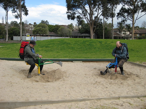
J and D play competitive digging! These diggers were pretty good. The fact that there are two makes for double awesome!
Now, at the end of the walk (as you can see if you check out the map) there was a 1km-each-way detour to visit some falls. Surprisingly, we all still felt pretty good at this point, so we didn’t even really consider skipping it. And I’m really glad we went! Because this was a lovely treat to save til near the end: the falls were lovely, but even better was the old paper mill on the opposite side of the river. It closed in 1927, and the aqueduct running around the side is a little broken in one place, creating its own waterfall.

The falls. We couldn’t be arsed walking all the way around and down to the bottom, so we sat at the lookout instead. We passed a family on their way down – one of the kids had fallen in. Whoops!

The old paper mill. People were climbing on it. It made me feel slightly ill.
We decided that it would be a lovely day out with a bunch of friends, even people who didn’t like walking. We could have a lovely picnic and explore the falls and look at the mill and dip our toes in the swimming hole . . . we had a bit of extra time to think about this, as our guidebook didn’t give us very good directions for the last leg. Luckily, we are all quite sensible and made our way back to the car in one piece.

The after shot!
I was personally a little surprised when I came home and mapped the walk – I didn’t feel like I’d walked 21km. In fact, it didn’t even feel as long as the Mordialloc-Carrum walk a fortnight previously. I think this may be due in part to it being new territory, and also to leaving morning tea and lunch to a bit later in the walk, making the last leg shorter. It probably also helped that we had such a leisurely lunch stop in such a nice location; it really broke up the walk nicely.
All in all, this is a lovely walk, and I recommend it. You can make it shorter by crossing the river at one of the earlier bridges (at the 2km, 4km or 6km mark) or by simply walking to the falls (this part is not wheelchair accessible, though).
So, on Sunday 26th July (LAST MONTH, OMG WHERE DID IT GO?) SJ drove us down to Geelong (GO CATS!) to do a walk along the Barwon River.
* Here is the map of our walk.
* Here are SJ's photos of the day.
* Here are my photos of the day.
I’ve been to Geelong a total of 3 times, I believe, and I always expect it to be more of an industrial wasteland than it is. In fact, our walk was absolutely delightful! . . . That is, once we got there – first we went hunting for a bakery, and the signs pointing to ‘shopping centre’ took us on a MERRY LITTLE JAUNT around the suburbs. Eventually we found a Brumby’s/Bakers Delight and got these amazing blueberry and white chocolate scones, which we nommed for morning tea!
Scone! Photo by SJ.
We started the walk in Fyansford, which is on the very outskirts of Geelong, and is quite attractive (at least near the river). Have some photographic evidence:
The before shot!
Barwon River. The reflections were amazing. I mucked around with them a lot!
A short section of boardwalk. Watch out for trolls!
Taken a bit further along the walk.
We went through the gorge, looking up at the houses high above the river. They weren’t very big. Once through the gorge, the landscape became a bit more built-up, although it still felt quite outskirts-y, rather than suburban. We got to see a bit more of the industrial heritage of the area, and learned about James Harrison (I keep wanting to type James Morrison or George Harrison!), editor of the Geelong Advertiser and The Age, and the inventor of the ice-making machine. He revolutionised the food industry! Oh my! He also has a bridge across the Barwon named after him.
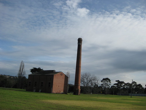
There were several of these, which I assume are old factories of some kind. Photo by SJ.
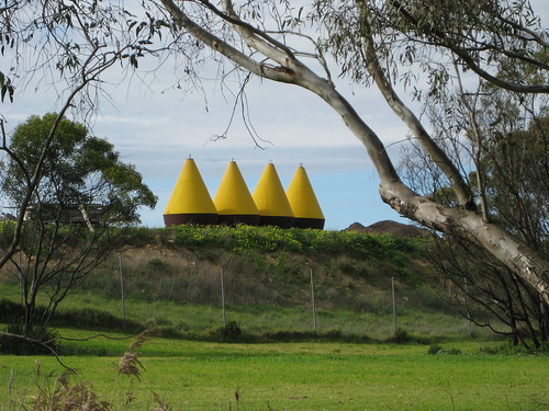
Conical things. Perhaps the book told us what these were, but I can’t remember. Photo by SJ.
D, standing very near the place that James Harrison invented the ice-making machine!
The Barwon is also used for rowing, and we passed a few club houses. Not as fancy as the ones on the Yarra! There were also signs up and down the river informing people of when and where they could row. SJ was able to answer all our rowing-related questions: Are those signs for rowers? Yes. What’s that thing? The finish line.
J’s new house, on the finish line. Photo by SJ
In case you hadn’t realised, this area is the ROWING AREA, OK? Photo by SJ
You can see the signs for rowing on the bridge. There were some pretty good bridges on this walk. Not that I’m a pervy bridge fancier or anything.
Anyway, the weather was pretty good to us. It was sunny in parts, cloudy in others. There was a bit of wind at times, but generally it was just a breeze to cool us down. We’d been threatened with “developing showers” by the bureau, but weren’t really affected by rain. This section about the weather here is to disguise the fact that most of the pictures between now and lunch are kind of boring! Have some pictures of spring-in-July!
Pink blossoms
Green willow
We eventually stopped for lunch at a little platform just off the path, down beside the river. Lunch was rolls stuffed with hummous, semi-dried tomato, rocket, boiled egg and roast potato. Delicious!
It was delightful! We wanted to stay a long time . . . so we did! Photo by SJ
SJ and J did the sensible thing, discarding shoes and socks and dabbling toes in the really extraordinarily cold water. Genius!
Lunch! NOM NOM NOM!
Immediately after lunch we passed the LOG CLEVERLY CARVED TO LOOK LIKE A SNAKE! There was a whole bunch of hilarious community craft and art along the walk, and our book seemed quite taken with it. We thought we’d get into the mood, and a lot of my photos of this section of the walk are rather silly.
It’s a log! Cleverly carved to resemble a snake!
Quidditch playing welcome in this park!
(Oh, also, for the record, half the public toilets on this side of the river were CLOSED AND LOCKED. Just FYI. You might want to relieve yourself when you can, even if you don’t think it’s strictly necessary!)
A very specific sundial! (They are BIG on mosaics in Geelong!)
J and D play competitive digging! These diggers were pretty good. The fact that there are two makes for double awesome!
Now, at the end of the walk (as you can see if you check out the map) there was a 1km-each-way detour to visit some falls. Surprisingly, we all still felt pretty good at this point, so we didn’t even really consider skipping it. And I’m really glad we went! Because this was a lovely treat to save til near the end: the falls were lovely, but even better was the old paper mill on the opposite side of the river. It closed in 1927, and the aqueduct running around the side is a little broken in one place, creating its own waterfall.
The falls. We couldn’t be arsed walking all the way around and down to the bottom, so we sat at the lookout instead. We passed a family on their way down – one of the kids had fallen in. Whoops!
The old paper mill. People were climbing on it. It made me feel slightly ill.
We decided that it would be a lovely day out with a bunch of friends, even people who didn’t like walking. We could have a lovely picnic and explore the falls and look at the mill and dip our toes in the swimming hole . . . we had a bit of extra time to think about this, as our guidebook didn’t give us very good directions for the last leg. Luckily, we are all quite sensible and made our way back to the car in one piece.
The after shot!
I was personally a little surprised when I came home and mapped the walk – I didn’t feel like I’d walked 21km. In fact, it didn’t even feel as long as the Mordialloc-Carrum walk a fortnight previously. I think this may be due in part to it being new territory, and also to leaving morning tea and lunch to a bit later in the walk, making the last leg shorter. It probably also helped that we had such a leisurely lunch stop in such a nice location; it really broke up the walk nicely.
All in all, this is a lovely walk, and I recommend it. You can make it shorter by crossing the river at one of the earlier bridges (at the 2km, 4km or 6km mark) or by simply walking to the falls (this part is not wheelchair accessible, though).
Subscribe to:
Posts (Atom)