26 July 2010

BELGRAVE - EMERALD - MENZIES CREEK, JULY 2010

It’s about time I shared some photos from our lovely anniversary (8 years!) walk, since it was a week and a half ago now! I really can’t be bothered writing up a big report (famous last words! I bet this will end up huge!), so maybe I’ll just post photos and have a ramble about them underneath each one. It was a nice two-day trip, and reminded us that walking for more than one day in a row is so excellent – waking up on that morning with nothing to organise except packing our bags and setting off was a truly relaxing feeling . . . not to mention that we only had a short day of walking ahead of us so we could take our time getting up and lounging around over breakfast (on which note, I do recommend Glenview Retreat B&B if you’re in the area).

Anyway, here is the map of our 2 day walk: click for map. I wouldn’t recommend people try to follow it exactly as we walked down roads that don’t actually exist on the ground and found ourselves having to cut through people’s paddocks and back yards a few too many times for our liking!

All our photos of the 2 days can be found here, or you can see just day one here or day two here. Now, on with the show!

the before pic!

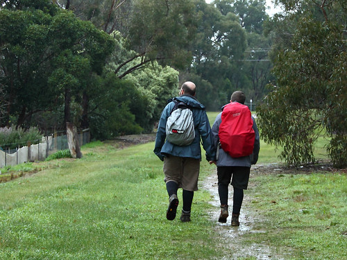
After our previous adventure and soaking, we'd come prepared for drenching rain, but apart from a few patches of drizzle on the first day, we didn't encounter much precipitation.

puffing billy in the morning

We said hello to Puffing Billy, knowing we would meet up with it again at the end of the next day . . .

sherbrooke forest, morning sun (2)

sherbrooke forest, morning sun (1)

. . . and headed into Sherbrooke Forest. It was quite spectacular with the morning light filtering through the trees and the bird calls echoing through the tree tops.

d and the morning sun, sherbrooke forest

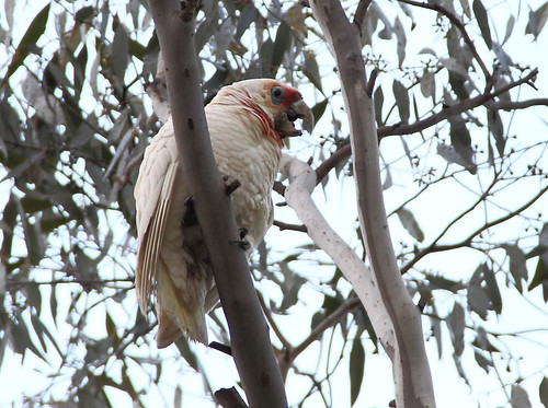
In fact, just after this photo was taken, a lyrebird strolled across the path not three metres in front of us! Then, five minutes down the track I said, "That sounds like another lyrebird" (you can often tell because it repeats the same half a dozen bird calls all at the same volume) . . . and then D spotted it up a tree! We stood and watched it singing for about ten minutes! Here are some little videos of it, taken with our photo camera:


Out of Sherbrooke Forest, we decided to brave Ward Road again - we weren't sure how much of it actually existed, but we knew the first bit could be walked and were hoping that we could cut through to the next road.

the top of ward road

The view is so great from there. It is actually kind of annoying that it's a view only property owners (and devious walkers) get to enjoy!

this is not a road!!!

This photo shows D on Ward Road - that straight blue line on the map is meant to be it. You can see the path behind him . . . not particularly road-y, is it?! Somewhat predictably, we scrambled along for a while and at some point decided that we should have hit the first road by now. With my super map-reading skillz, I led us down the hill to the tops of the gardens, and we stepped over a low fence (strange how much of a psychological barrier a flimsy fence can be: you are now DEFINITELY trespassing!) . . .

trespassing!

. . . and into a vacant block. We then traipsed down to William Road, walked for another kilometre or so, and then sat down by the side of a quiet road to enjoy the view and have 'morning tea' (at about midday, if I recall correctly). A couple of goats looked on from a shed above us as we picked out which house we would live in and debated whether or not we'd have to also buy a car to get around.

d and morning tea

perspective

After a bit more roadside walking - and more mysterious non-existent roads on the map - we headed onto the track beside Sassafras Creek (called the Sassafras Creek Forest Trail, the Dandenong Tourist Trail or Track and other names).

the path beside woori yallock ck, nr emerald

It was beautiful, but hard(er than expected) going in patches because there were some trees down across the path - one huge one that we had to caterpillar over in stages, throwing our bags across and digging our fingers into the bark as we scrambled across - and the winter rains had turned parts of the track into slippery mudslides and mini-waterfalls. We saw some cool mushrooms and fungi, though.

footsteps in the mud

Geastrum saccatum (1) teeny mushroom colony

We sat down for a quick bite to eat at around 2 or 2:30, a bit rushed because rain threatened, and also because we were aware that due to a late-ish start, some dawdling (the lyrebird!) and some slow going (Ward Rd!) we were going to have to make up some time in order to get to our B&B before dark.

oh hai.

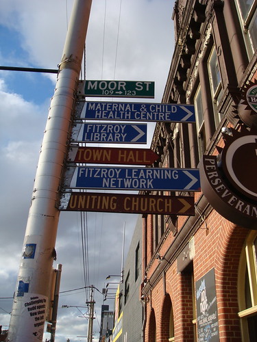
Also, I had a headache. The stretch along the creek before lunch had unfortunately just seemed to go forever, but now we were on Woori Yallock Creek (of which Sassafras Creek is a tributary) we made good time, and soon we were emerging onto the outer fringes of Emerald. We climbed the steep hill onto Prince St and followed roads into the town itself.

back yard alpacas

Back yard alpacas!

us! in emerald!

Us in Emerald! D used the facilities near the library, then we toddled down into Emerald Lake Park - highly recommended for a picnic and a stroll, and conveniently located next to a Puffing Billy stop (maybe it's actually the other way round)!

emerald lake

The park is a lot bigger and the lake a bit smaller than I'd imagined, and I could easily spend a day exploring. In peak season it must get busy, what with the train, a little swimming pool, lots of waterfowl, an outdoor gym, paddle boats and various picnic areas to draw the crowds.

paddleboats on emerald lake

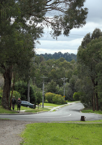
We crossed the bridge over the lake, got a little bit mixed up with unsignposted walking tracks, and ended up (once again) sneaking through a back yard in order to get onto Bower Ct. A few corners later and we arrived at our B&B to be greeted by our friendly host (Jenny), a bottle of red wine, a bowl of chocolates, and a wonderful suite.

glenview b&b

glenview b&b

We had a long soak in a hot bath - actually, it was a spa, but we didn't really want to use the spa function - drank our wine, ate the chocolates, watched Legend (haha, I know!) and slept wonderfully. (Some of you will be pleased to know that a little note beside the spa asked us to leave the water in after the last use so that it could be used to water the garden.)

*

The next morning we lazed in bed for a while, having ordered breakfast (from the menu!) for 9/9:30, and sat out on the balcony in the fresh morning air, wrapped in our bathrobes.

d in a bathrobe view from the balcony of glenview b&b

As we ate breakfast, Jenny came by our little courtyard and put out some seed . . . and suddenly the yard was full of lorikeets and galahs! It was all very lovely, and what we really wanted to do was STAY FOR LONGER. Instead, we slowly got ourselves together, settled our bill, said goodbye and headed back down to the lake . . .

the path at emerald lake

. . . up to town, where we caught a few glimpses of wonderful views across the hills . . .

view towards mt donna buang from emerald

. . . through some vacant land, and back down to the creek.

desire path, emerald

Heading up along Ridge Road, we were less concerned by the 'no through road' and 'private access only' signs (the map clearly stated that there was a walking track!), and more concerned with the size of the hill looming before us! We were aiming for the trig point and picnic area marked on our map as having 'excellent views', so we knew there was going to be at least a bit of a climb!

farm valley

ridge road reserve, johns hill

As we toiled up the hill, though, we reaped immediate rewards - the views seemed to unfold around us. First we could see just the next hill, then the next, then all the way across to Mount Donna Buang near Warburton!

view (wih bird) northeast from ridge rd reserve, johns hill

From the top, the view was absolutely stunning. We could see the Yarra Valley, Donna Buang, Mount Beenak, and Silvan Reservior.

view northeast from johns hill trig point

Panorama of the Yarra Valley from Johns Hill lookout

And that's just showing you the vista to the north-east! As we sat at our picnic table with the sun on our backs, we drank tea, ate chocolate, and soaked in the view to the south and south-east. From here we could see Cardinia Reservoir, Western Port Bay and French Island, Arthur's Seat on the Mornington Peninsula, and glimpses of Port Phillip Bay to the south-west. We also wondered if the hills in the distance might be Wilson's Prom - they were definitely South Gippsland, anyway!

view sou' sou'east from johns hill (1)

This was pretty much as good as it was going to get! We would have been happy to stay until sunset, but we needed to get back down to Menzies Creek and catch Puffing Billy back to Belgrave.

j  at johns hill trig point (1)

Yeah, I'm a peak bagger! ;)

"little lord trumpington has come out to play"

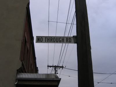
I should take a moment to point out that we had, for some reason or another, found the word 'Trumpington' very amusing the previous day. We thought it sounded like a euphemism for farting, and so we'd devised various phrases - the ones that caught on were all about Little Lord Trumpington: "Little Lord Trumpington has come out to play!" and, "Did you invite Little Lord Trumpington along to dinner?" and suchlike. Hopefully this explains D's pose in the previous photo! You might also notice the big sign saying "LOCAL TRAFFIC ONLY". There was also one saying "No through road". Having walked along so many roads marked as such, and having found them at least a little walkable, we ignored the signs.

trumpington grove started off so promising . . .

It started off fine . . .

. . . and remained fairly promising for a while . . .

. . . and continued to be more than adequate for quite a while. But then it simply disappeared, and we were faced with the prospect of climbing all the way back up the hill and continuing mapless to Menzies Creek via another route (we hadn't photocopied an alternative). Or, we figured, we could just continue where the map said the road was meant to be and get to Menzies Creek that way - after all, we were so close! We could pretty much see the town. And so . . . we pushed on. First on the outside of the fence, and then, when it got too steep and scrambly, over the fence and into the paddock we went.

. . . before disappearing completely!

We weren't too happy about this turn of events. Particularly as some of the fences looked like they might have been electric (I tested them with a blade of grass, they weren't on), and then even more so when a young bull started running at us! Luckily it was just curious, not angry, but we scarpered into the next paddock! By this stage we were well and truly concerned, and wondered how lost we might actually get.

If you look at the map linked at the start of the post, you will see that Trumpington Grove is meant to curve west to meet Belgrave Gembrook Rd, and we hoped that there would be some kind of bridge or ford across the creek at that point. There wasn't. There was, instead, a large, wet swamp. We considered our options. We could wade across the swamp? After all, it was the very end of our walk, so we wouldn't be uncomfortable for long. It didn't seem appealing, though, so we decided to follow the creek around for a bit to see if there was an easier crossing point. After all, we'd trespassed so much by now - in for a penny, in for a pound as they say. And there was! There was a little land-bridge across the creek at the end of the paddock! All we had to do was go through the sheep pen (making sure to close the gates properly behind us) and up through the back yard of the house onto the main road. The sheep were quite happy to see us, and one in particular seemed keen to nibble on whatever we might have to offer (our packs, for instance). We patted them, took a deep breath, and started to climb out of the creek.

Someone came running out of the house, so we called out our apologies and checked with them that we were actually in Menzies Creek (at this point we were just happy to see a person). She said yes, but also said we were lucky she was home, because their dog was "very unfriendly", and who knows what it might have done to us if she'd not been around. She let us hop over the gate and onto the verge of the road, and as soon as we'd gone she let her dog go. It snarled and barked and was generally ferocious, and we were very glad that everything had turned out OK. (I should point out that I had a long-lasting, very intense fear of dogs after being "chased and mauled" - more like "played with and licked on the face" - by one that was bigger than me when I was about three or four years old, and I would actually rather face a bull than a large dog!)

Needless to say, there are no pictures of this.

We power-walked up the road and scampered into Menzies Creek station just as Puffing Billy arrived. A kindly conductor took pity on us when we asked him if we could buy a ticket from him (I think you're meant to pre-purchase - well, now we know) and pointed us to a carriage.

menzies creek station

d & j : the after image on puffing billy

It was with some relief that we sat back to admire the view as the train pulled out of the station. I'd been a bit worried about the trestle bridge, because I remember being terrified when we went over it when I was a kid! However, I think I'd used up my worry for the day! The bridge seemed quite small and solid this time round!

out the window of puffing billy

j & puffing billy

At Belgrave, we noticed our friend's car at her mum's house and we dropped in to say hi. We were treated to cups of tea and slices of delicious home-made lemon tart, and we stayed for an hour or so, patting the cats and chatting. Then E drove us home, and we sang Beatles songs all along the freeway. It was an unexpected and lovely end to our trip.

A+, would walk again. But not along Trumpington Grove!

23 July 2010

SIGNS

An interesting bit of trivia over on Sociological Images about street signs. Lisa commented that in New Orleans, many of the corners have the street names embedded in blue and white tiles, like this. Her comment was that such signage is of no use to motorists, and isn't it interesting that such things were planned with pedestrians in mind?

This reminded me of how quaint I found much of the signage in the UK when I first visited, because a lot of the street signs are less than a metre off the ground, and are positioned 'behind' the pavement on fences, etc. Again, great for pedestrians, but can be annoying for newcomers trying to navigate around! Luckily, however, it's almost impossible to drive quickly through London city back streets (for e.g.) because they were not built for cars! Here are some (naughtily hotlinked) examples:


In Melbourne (and Victoria generally), street signs are much higher off the ground, and most often right on the corner of the street (on telephone (telephone?) electricity poles or on their own poles). They're also quite a bit smaller. It's interesting to see the difference in perspective of all the photos when googling for images of London street signs and Melbourne street signs! Again, apologies for hotlinking.


Anyway, I just thought it was interesting. Mainly because I am kind of fascinated by signs, and street signs are so ubiquitous and so location-specific, yet most people hardly think about how they change the landscape visually, and how they construct the environment spatially.

12 July 2010

WALKING OUT OF THE CITY: DAY FOUR

Saturday 3 July 2010
Ringwood to Lilydale
23km / Approx 7 hours
Map
My photos


the before pic
G, J & D just beside the freeway in Ringwood: our ‘before’ picture


“A shift in atmosphere or perspective”. That’s what I wrote in the first post in this series about walking out of the city, thinking about boundaries and subtle borders that only appear obvious in the crossing. The shifts I’ve mentioned so far have been from inner to middle suburbia (and now from older to newer outer suburbia), from river- and creek-side paths to roadside walking, from more-accessible to less-accessible terrain, from familiar to less-familiar, from MFB to CFA territory and back again, from the hard surfaces of asphalt to loose gravel or soft grass underfoot, from residential to agricultural/horticultural land use, from the solid, regimented lines of human construction to the more relaxed, fluid shapes of ‘nature’. And all the while, the boundary most obvious is between city and not-city.


Bear Grylls would surely not go adventuring in the city! We must have entered the wilderness! (Photo by GT)


In all of this walking and investigation I wonder if, more often than not, I have been searching for a spatial border (or borders)? Or have I been walking to the (re)realisation that physical, geographic, cartographic and administrative circumscriptions are only one way of locating a city? I’ve been reading Benedict Anderson on imagined communities, and although he uses this phrase to refer to nations, the concept might also be applied and adapted to any number of networks, groups, communities – including that of ‘the city’. In this formulation, then, spatial boundaries are only one way of imagining the city. Other imaginings occur through music (songs like Carlton (Lygon St Limbo) or Four Seasons in One Day, or one of these other songs), or sport (an imagining of the city through AFL or VFL clubs, for example), or news about violence (gangland killings, anyone?), or the daily interactions we have with other people in schools, shops, workplaces, on roads or bike paths, with cleaners or bankers or ticket inspectors (“I suggest you take a long hard look at the reflection of yourself in the tram window in your deceptive, unattractive plain clothing uniform and ask yourself,” recites Yana Alana, “Was it always my dream to become a ... motherfucker?”). This is the city as imagined through the circulation of local newspapers, the dissemination of home delivery menus, discussions of the weather, the suggestions to visitors that they try this restaurant or that bar, wearing of badges with Melways maps on them, community mapping projects like ToilArt and Feral Fruit Trees, coffee snobbery (which has surfaced a few times in this series of posts!) and speculation about whether ‘we’ will vote Green in the next election now that Lindsay Tanner is resigning. The urban city might be imagined in relation to the suburban sprawl, rural farmland or remote bush. Melbourne might be imagined in relation to Sydney (From St Kilda to Kings Cross) or Adelaide, in relation to Victoria, in relation to Australia – or in relation to major cities in Melbournians’ countries of birth (UK, Italy, Vietnam, China, New Zealand, Greece, India, Sri Lanka, Malaysia and the Philippines were the top 10 in the 2006 census). Present-day Melbourne might be imagined in relation to Melbourne of 20 years ago (see the clip for the Skyhooks’ Lygon St Limbo, above), or the colonial town of 150 years ago, or the pre-colonised land of the Wurundjeri, Bunerong and Wathaurong people. At any rate, this Melbourne and this idea of the city coheres around psychic and interactive (person to person, to environment, to institution, etc) elements, rather than being circumscribed by spatial boundaries . . . in which case, how might one walk out of the city?

ringwood suburb, you have my apologies
The back blocks of Ringwood, next to the Mullum Mullum path

some kind of eucalypt flower
Eucalyptus of some description, Croydon Hills


Croydon Hills. (Photo by GT)


Perhaps it’s that as we walk further ‘out’, I walk further from ‘my’ city, the place where I spend my everyday. This much is obvious in my continued surprise at the suburb of Ringwood – mentioned last time as being quite nice, really, and living up to that standard during this leg of our walk. We used the facilities in Eastland (what an exciting experience!), then headed to the Mullum Mullum path, ducking under the freeway and heading into the quiet Saturday morning suburbs. We saw Maned Wood Ducks, some mallards, lots of joggers and dogs – including one adorable black puppy called Bella, who was very friendly and happy to meet ALL THE PEOPLE EVER! After about 6kms, we left the creek and followed streets (mostly with footpaths, unlike our road-walking sections through Park Orchards last time!) for a few Ks to the section of bushland called Hochkins or Hodgkins Ridge Flora Reserve. We weren’t sure that there’d be tracks through the reserve, but luckily there were (for anyone following our footsteps, you need to take the second gate into the reserve – the first path leads down to the creek). The rain that had been threatening all day finally descended before we had the opportunity to break out the thermoses – we were really hanging out for a cuppa by the time we got to our lunch break a few kilometres later. In the interim we enjoyed the rest of our time in the reserve, then turned east along the road at the northern end. My Melways says that this is the proposed route for a northern arterial road, so we made sure to enjoy the peace and quiet and our ability to meander across the grass by the roadside, because in a few years time it might be gone. Turning south again, we passed by a primary school and – more interestingly – some hilarious goats, before finally trudging to the shops on Exeter Rd in Croydon North and settling in under the shelter of the op shop verandah for food and tea.

g & d brave the drizzle
D&G before the rain settled in, walking through Hochkins Ridge Flora Reserve

g & d: raincoat hoods up!
G&D with hoods up against the rain, a few minutes later!

OH HAI, I'M A GOAT!
GOAT!!!

g & d eating lunch
Food and shelter! Excellent!


The differences between here and, say, Thornbury at the start of this walk, are quite significant. Although we might both consider ourselves Melbournians (or Melburnians, if you prefer that spelling), my Melbourne is going to be very different to the Melbourne of someone who lives in a big house in Croydon North (not an apartment in the inner northern suburbs), commutes to a full time job in one of their cars (not to a part time job on the tram or to uni on foot), who sees the city from wide suburban streets, a freeway or bypass (instead of from laneways, bike paths and CBD streets), who drives their kids to school, sport or music lessons (no kids, no car) . . . We sat under the verandah and watched this other world go by. People said hello to us, smiled, or rushed to their cars as the rain picked up again. We wondered how much our white/age/class privilege allowed us to set up here and have a picnic lunch where others might be less welcome or more likely to be told to move on and stop loitering.

ESTHER CR.
I thought some of the Esthers in my life might like this!


Having talked about how my imagining of ‘the city’ might differ from someone else’s, I should also mention that my own ideas of ‘the city’ and of Melbourne are also in constant flux. When I was a kid, my family used to drive 400+kms from the bush in East Gippsland to Melbourne to visit family during school holidays. Mostly we would stay with my Oma, and I remember ticking off towns and getting more exciting the bigger they became: Bairnsdale, Sale, Traralgon, Moe (almost an outer suburb in my mind!), Berwick (definitely in Melbourne!) and then finally our destination – the overwhelming metropolis of Croydon! To me, the area around Croydon was Melbourne, it was the city, and I could barely differentiate between Croydon and the CBD (the only real difference was that the big gallery was in the latter, and the trains went underground). It’s funny to think that now Croydon registers as an outer suburb to me – meaningful only in memory (“I know where we are,” I said as we crossed the end of Dorset Road, knowing I could walk a few kilometres – right on Lincoln Rd, left on Croydon Rd – and be at Oma’s house . . . only it’s not Oma’s house any more, and I would probably have cried), and in relation to other places (it now seems so close to the Dandenong Ranges National Park – a favourite walking haunt of ours). It’s also strangely familiar and unfamiliar now, because not only have things actually changed, but my perspective on them has changed, particularly as a walker rather than a passenger in the back seat of a family car.

BUTCH
D in Mooroolbark. I thought I was being very amusing making him pose for this photo.

pipeline, mooroolbark-ish
We walked a few kilometres along the path of this pipeline.

g on the pipe track
You can see all the new suburbs springing up before your eyes. And hardly a solar panel in sight.


Consulting the map! (Photo by GT)


And off we go! (Photo by GT)


Walking along the pipe reserve reminded me a bit of walking to Epping - and how interesting that the linked post also talks about the yearning to walk out of the city! I realised that this ‘reminds me of’ game is one that I’ve been playing since we left Eltham, since we started walking where we’d never been before. I guess most people do this without thinking: “This street in Melbourne reminds me of that street in Berlin”, “These tube station names in London remind me of suburbs in Melbourne”. This seems to create a psychic palimpsest of the city – the London underground map sits distorted over Tottenham and South Kensington, the Rose St market in Fitzroy sometimes merges into the flea market in East Berlin, the smell of coffee and sewerage near the Queen Victoria Market invokes echoes of Barcelona, the crowds of tourists in Fed Square (FEDDO!) pale in significance with the claustrophobic summer throngs of Rome or Venice, and whenever I travel on the Tullamarine Freeway I get a little thrill of travel excitement and remember all the other airports I’ve been through in Singapore, Canada, Japan, New Zealand, Hong Kong, London, Abu Dhabi, Amsterdam . . . This city is personal, psychological, emotional, and clearly a result of individual circumstance.

someone to watch over me
Street art – another thing Melbourne is known for. Although usually it’s the art in the inner city laneways that gets all the attention.


Well, this post has been rather heavy on the abstract, and hasn’t focussed as much on the actual walking experience! I suppose that story comes through more in the photos and captions (it’s rather like a supplement in a Derridean sense – OMG theory wanker!). It was, overall, a really lovely walk through some unfamiliar (to us) territory. We all enjoyed the Olinda Wetlands and Lilydale Lake in particular. In fact, the last section of the walk was probably the most spectacular, which is always a good way to end! Lilydale Lake was a wonderful mirror of the sky as the cloud lifted, the rain stopped, the sun set and evening fell, and we agreed that the lake and wetlands would make a lovely afternoon outing for a picnic in drier weather.

olinda wetlands with rising cloud
Olinda Wetlands

olinda wetlands reflections
We joked that we’d walked on the toe-hills (rather than the foothills) of the Dandenongs, but the heavy cloud meant we didn't really get to see the hills for most of the day. The cloud only started to clear towards the end.


Long-billed corella making a racket in the tree beside our picnic table. (Photo by GT)

lilydale lake reflections 2
Lilydale Lake – how’s the serenity?!

lilydale lake reflections 3
There are even little beaches around the side of the lake!


This day of our walk to Warburton, alongside the reading I’ve been doing, has lead to a shift in my perspective. In a way, I am now inclined to see the line that our footsteps have traced as evidence of the city (my city) expanding, and also as part of an extension of what ‘the city’ in general (and ‘Melbourne’ in particular) means to me.

the after image: long exposure and creepy eyes!
Tired out after a long day. The train ended up packed with Collingwood supporters on the way to the Saturday night game at Docklands – what did I say about Melbourne being imagined as footy town? It’s true!