This walk was a close copy of our ill-fated first attempt a couple of weeks earlier. HAWT was once again joined by G (we all looked at his elbow and went 'ooh' and 'ew', etc) and also by J (as this might cause some confusion, I will call myself N for nix in this post). We met at 9:30am on Good Friday where Moreland Rd crosses Moonee Ponds Creek, allowing me and D to catch the bus instead of a taxi.

G, J, SJ & D setting off.
We made pretty good time along the path, knowing that a delicious morning tea of freshly made hot cross buns (SJ is a genius, I tell you) awaited us. The weather was slightly cooler than on our previous attempt, with some occasional and very welcome cloud cover.

J, SJ & D lurking under the bridge.

Morning tea spot. Photo by G.

Amazing vegetarian (i.e. golden syrup glaze) hot cross buns by SJ.
Over morning tea (we felt quite pleased with ourselves for eating holiday-appropriate food), we discussed the idea of making a book combining our passions: food and walking. We thought we would call it Baked Goods and Bridges I Have Known. What do you think?
After that, we trundled along through the suburbs on the other side of the creek from last time, under the trestle bridge (we stopped to admire it again, but not for as long) and into the Jacana wetlands. We paused for a standing snack (dried fruit) to keep up our energy until lunch, which was not too far away!

J, SJ & D crossing the creek at the stepping stones.
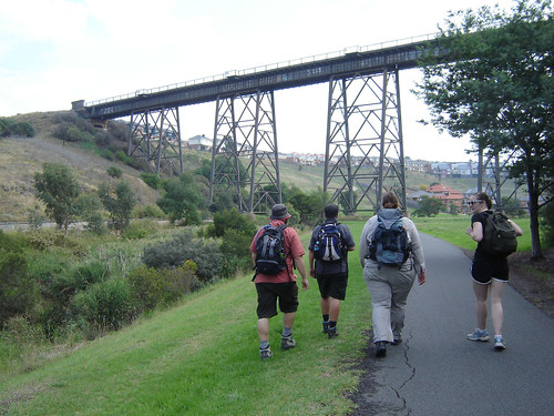
D, N, SJ & J heading towards the trestle bridge. Photo by G.

Lunch! It was a very successful banquet!
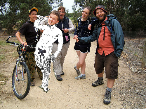
Lunch was delicious - roast potatoes, fried rice, veg sushi, cornbread with honey, carrots and cucumber with dip, and chocolate to finish it off. NOM NOM NOM. After lunch, we continued with some trepidation past the site of G's accident on our last walk. All went without incident (yay) and we crossed the creek into CFA land: THE COUNTRY! I wanted a photo to commemorate the occasion, and I said I'd photoshop myself in later. I didn't but G kindly did:

Hot! From here, the path climbs gently through some messy but interesting semi-wasteland to the foot of Gellibrand Hill, affording a view over the creek towards the airport (there is some runway noise at points). It seemed quite soon that we arrived at the wildlife fence and passed through the gate into Woodlands Historic Park. It's nice to finally be in amongst the trees, especially when it's sunny and you're beginning to sweat off your sunscreen!

Thistle plants. Photo by G.

G & SJ go to visit J & D in their wildlife prison!
The ascent coming at the end of the walk was hard, but thankfully it isn't too long or too steep, and we were rewarded with kangaroos as we started the final climb up Gellibrand Hill past the radio tower!

And then, the top of the hill! There were a couple of other people around, but we mostly only shared the view with the kangaroos, a cup of tea, and more hot cross buns. Given that the hill is only 204m above sea level, it does give you very good views almost all the way around. Unfortunately it was a bit hazy when we were up there, so the city was muted blue and silver on the horizon, but we pulled out the map and charted where we'd come from.

DB at the summit! What a peak-bagger!
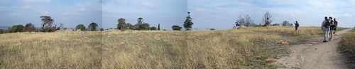
Panorama by G.

More ideas for walks and views!
We poked around the Dundonald Homestead ruins for a bit, scared a few rabbits, admired some trees and some walls, then headed down to the main road and waited for the lovely E to pick us up. I don't know how she puts up with our stinkiness, honestly!

G admiring the stables. They were better preserved than the house!
All in all, a successful adventure. No injuries, lots of good food, lovely people and a view at the end!
Review of Moonee Ponds Creek Trail
Now, a couple of people have mentioned to me that I don't really rate/review the walks we do and the trails we use. I guess that's because I started out doing this as a diary rather than as a review site, and also because I enjoy walking and discovering things to such an extent that it doesn't matter that much where I do it (with massive exceptions, like the UK being much more walker-friendly than Australia, or mountaineering not being the kind of 'walking' to which I aspire)!
That said, I guess this path is not one of the most attractive/interesting waterside trails in Melbourne - it is pretty flat aside from a very wee climb in the middle and the hill at the end, and apart from a few sections of creek and Woodlands Park at the end, there aren't a lot of nice tree-filled areas. However, it does have one major thing going for it: a sense of progression. I must admit that I am a total sucker for walks that take you from city to country, and the Moonee Ponds Creek Trail (with the extension to Gellibrand Hill) does that magnificently. You start on the edge of Brunswick and walk along the creek through outer suburbia in all its glory - Citilink overhead, the 1970s brick units, the TV antennae, the dry ovals, the new housing estates. Then there's the giant trestle bridge, which quite frankly makes the entire walk worthwhile! You hit the long, exposed basin of the Jacana Wetlands, and there's a good chance of seeing some interesting birdlife on both sides of the Western Ring Road. This section is something you should particularly note, as a proposed freeway extension may soon make a huge scar alongside the valley. From there, the path curves away to the west and takes you through the last of the suburbs (Westmeadows), out of MFB territory and into CFA territory.
At this point of unclaimed, BMX-track and rubble-strewn land you start a gentle but noticeable climb, and you can see the Tullamarine Airport and Age buildings close by. Crossing the into Woodlands Historic Park, you follow the fence north for a way, with bush and scrub to your left and horse paddocks to your right. Gellibrand Hill has been in view for a while, and now you curve around the bottom to approach it from the north. If you're lucky you will see a mob of kangaroos grazing and lazing near the radio tower. Although it might be tempting to cut directly up the hill from the south, circling around means that you are rewarded right at the end with a magnificent view back towards the city. If you have OK visibility, you can trace the route you've walked and congratulate yourself on how far you've come over a cup of tea.
I give the walk THUMBS UP!

More of my photos from the day can be found here. An approximate map can be found here.
\o/ Thumbs up indeed! What a triumph, and I'm glad the third time was the charm! :D
ReplyDelete(Also, I'm really amused that your ACTUAL walking marathon took place on the same day as my exhausting Star-Wars watching, ass-sitting "marathon"-in-serious-airquotes. All that TV was EXHAUSTING.)
a total triumph. all the more awesome because of the piddly nature of the actual hill!
ReplyDeleteYAY FOR V V SRS MOVIE MARATHONS!